Historical Maps!

For those who love history, maps, or both(!), it is interesting to track the progression of development surrounding the land that is now Glen Providence Park! We’ve compiled over 20 maps in chronological order, starting with property lines of European settlers in 1681. Early maps were of Chester County, before Delaware County was founded in 1789. Some of the locations and property owners play a part in the park’s history and folklore, as noted in the captions.
Most of these maps are zoomed in from larger maps, focusing on the valley that is now Glen Providence Park. Not all maps are oriented with north at the top, some are almost sideways! The best way to orient yourself is often to find Broomall’s Run, which runs the length of Glen Providence Park, and is shown on most maps.
Thank you to the institutions and organizations that have preserved and displayed these wonderful maps: Delaware County Institute of Science, Media Historic Archives, DelawareCountyHistory.com, Delaware County Courthouse, Delaware County Parks & Recreation, and Brandywine Conference & Visitors Bureau at Rose Tree Tavern. Below the map gallery, there are links and more information about each institution, along with a listing of which maps we found there.
Scroll through time below – you can click on any map for a closer look!
-
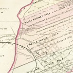
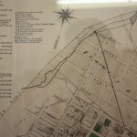
- 1681 Map of the Province of Pennsylvania – Glen Providence Park is on the north-west edge of the land owned by Peter Taylor. Broomall’s Run met Ridley Creek on the south-west corner of Allen Robinet’s land. And notice that Ridley Creek was then named Preest Creek!
-
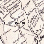
- 1683 Map of Chester County – Ridley Creek is in the center, with Crum to the right, and Chester to the left. The park would be just north of the center, to the right of Ridley Creek, on the land owned by Peter Taylor.
-
- Map of the Township of Upper Providence from 1882 showing early grants & patents – this illustrates the progression of land ownership, starting with Peter Taylor in 1681. Broomall’s Run is the stream running across the center.
-
- Map of the Early Settlements of Delaware County from 1862 – Broomall’s Run is above Peter Taylor. Note the Minquas Indian trail running past what is now Long Point Wildlife Sanctuary in Rose Valley, and that Ridley Creek is called Stille’s Priest Creek.
-
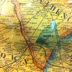
- Historical Map of PA from 1875 – putting Media in a wider context of regional events.
-
- 1785 Map of Chester County – marking the Middletown Presbyterian Church from the Newlywed Ghost Story.
-
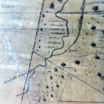
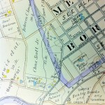
- 1810 Map of Delaware County – Ridley Creek runs down the center, along the orange boundary line. Broomall’s Run is along the word “Providence” – the park would be under the “PR”. The road along the top of “Providence” is Kirk Lane.
-
- 1848 Map of Delaware County – the park is in the center. The creek running along Isaac Cochran’s property is Broomall’s Run, and the road above that is Kirk Lane.
-
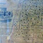
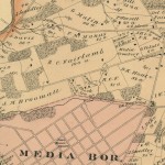
- 1855 Map of Media, with Third Street before it extended West across Broomall’s Run – which was then the source of drinking water for Media Borough, and was divided into 2 streams.
-
- 1855 Close-up showing the Shingle Mill Stream that was diverted from Broomall’s Run within what is now the park – to power the shingle mill near Ridley Creek.
-
- 1860 Map of Chester County – locating the shingle mill near Ridley Creek.
-
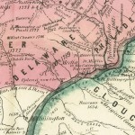
- 1870 Map of Media & Upper Providence – this shows the water works not far from where the swim club is now. The “F. Cannon” house in the valley plays a part in the “Witches Ride” Story.
-
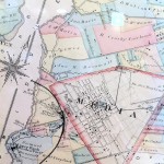
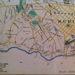
- 1870 Plan of Borough of Media – Broomall’s Run is along the Borough line at the top. When Broomall’s Run was used as the Borough’s water supply, there was a reservoir and waterworks near Orange Street, upstream from the future Broomall’s Lake and Glen Providence Park.
-
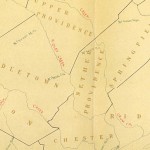
- 1875 Map of Upper Providence Township – one of the last maps before Broomall’s Run was dammed.
-
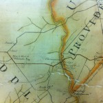
- 1892 Plan of Upper Providence – with the new Broomall’s Lake, which was created around 1883 by Judge John M. Broomall to harvest ice.
-
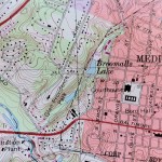
- 1892 Map of Media – shows the ice house used to store ice from Broomall’s Lake.
-
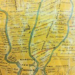
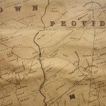
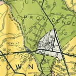
- 1909 Map of Upper Providence Township – the “Scrogie” estate (usually spelled Scroggie) gave Scroggie Valley its name. It also shows the Palmer family property where T. Chalkley Palmer grew up, and George Butler owning the “Broomall House” at Front and West Streets.
-
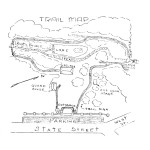
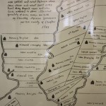
- 1941 Nature Guide Map to Glen Providence Park – we believe this was drawn by long-time park guard, James Stokes, Jr.
-
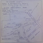
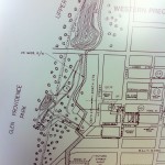
- 1945 Plan of Glen Providence Park – showing the trails, footbridges and structures built by the WPA, many of which remain. It also confirms the location of the original drinking spring by Broomall’s Dam.
-
- 1946 Delaware County Road Map – indicating the Media Waterworks is the center of Delaware County!
-
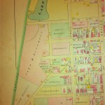
- c. 1951 Map of Media – this map shows trails somewhat different than the park has today- with a footbridge crossing Broomall’s Run near the 3rd Street Waterfall, and another downstream from the pond. Neither footbridge still exists.
-
- 1995 Media Quadrangle – illustrating the park’s steep topography!
Sources:
Media Historic Archives:
Archival material about Media Borough and vicinity – including photographs, manuscripts, and maps! Located in the Media-Upper Providence Free Library, Media, PA. You can visit by appointment, during library hours.
1855 Map of Media the Seat of Justice Delaware County, Pennsylvania by Thos. Hughes, C.E.
1892 Map of Media
1909 Map from the “Property Atlas of Delaware County East of Ridley Creek”
1941 The Nature Guide to Glen Providence Park issued by Delaware County Park and Recreation Board
1951 Borough of Media, Delaware County, Penna
Delaware County Institute of Science:
One of Media’s hidden treasures, with a wide array of collections, right on Veterans Square in Media! Open most Monday, Thursday, and Saturday mornings, 9:00am – 12:00noon.
1681 Fac-simile of Holmes Map of the Province of Pennsylvania with the names of the original purchasers from William Penn – begun in 1681 (reproduced in 1846)
1683 A draft of some part of the county of Chester in Pensilvania by Charles Ashcom Surveyor
1810 A Map of Delaware County as Divided into Townships
1848 Map of Delaware County by Joshua W. Ash, M.D. from original surveys with the farm limits
1870 Plan of the Borough of Media, PA by G.M. Hopkins, C.E.
DelawareCountyHistory.com:
An impressive collection of documents and maps (more than we show here!) are scanned and well organized on this website – available 24/7!
1785 Township Map of Chester County Pennsylvania by Joshua W. Ash, M.D.
1862 Map of the Early Settlements of Delaware County, Penna – from George Smith’s 1862 History of Delaware County
1875 An Historical Map of Pennsylvania by P.W. Sheafer and others – Historical Society of Pennsylvania
1875 Map of Upper Providence Township
1882 Map of the Township of Upper Providence showing the Early Grants & Patents
1946 Map of Delaware County, Penna. produced by Office of Engineer of Delaware County, A.C. Throne, County Engineer
Delaware County Parks & Recreation:
1945 Plan of Glen Providence Park by J. Earl Kirk, Engineer
Delaware County Courthouse:
On display in the 2nd floor lobby by Council Chambers, along with an 1860 map of Philadelphia and Vicinity:
1860 Map of Chester Co Pennsylvania by T.J. Kennedy
Brandywine Conference & Visitors Bureau at Rose Tree Tavern:
1870 Map from the Atlas of Delaware County, Pennsylvania by Henry W. Hopkins
Personal collection:
1892 Plan of Upper Providence Township from Atlas of Delaware County by J.L. Smith
1995 USGS Media Quadrangle Map
We will add more maps of interest as we find them!
Related Posts
-
 9-14-2024 Our final concert!
Posted on Aug 19, 2024
-
Third Street Bridge: Design Considerations
Posted on Aug 19, 2024
-
Celebrate the Park’s 88th Birthday!
Posted on Sep 29, 2023
-
Third Street Bridge to be Pedestrian-Bicycle Only
Posted on Jun 16, 2023
Tags
Share This


Recent Comments