The 1.1 Acre Project

It’s our 2013 project to document the plants and wildlife in Glen Providence Park! We’ll continue our photojournal of the whole park, but this year we’ll focus our efforts on one acre of the park- the construction area for the 3rd Street Dam.
We don’t know when construction will start to replace the dam, but it may be as early as 2014. Whenever it starts, according to the project engineers, 1.11 acres will become a construction area, with approximately .64 acres buried with earthfill. So, in order to appreciate the 1.1 acre while it lasts, we will document it over the next year!

The trees marked on Philly Tree Map are within the 1.1 acre construction area
The perimeter:
Last year, we used the dam construction diagrams from the project engineers at Larson Design Group and Schnabel Engineering to identify the perimeter of the construction area. We then registered 76 trees within that area on Philly Tree Map– some of our favorite of the 18 tree species we found there were Umbrella Magnolia, American Sycamore, American Witch Hazel, Sassafras, American Hornbeam and Black Tupelo. The resulting tree map shows the perimeter of the 1.1 acre construction area.
History:

1930’s or 40’s photo of footbridge near waterfall. Posted with permission of Media Historic Archives.
The acre has changed through the years, as you can see from early photographs. There was once a rustic footbridge across Broomall’s Run, where the path led through a fernery at the base of Broomall’s Dam to a drinking spring on the Upper Providence side. That spring is still there, but difficult to access- and it is right on the border of the construction area, at the base of an enormous Tuliptree. We cleared part of the then-disused path leading to the spring at our second volunteer day in October 2011. A footer from the footbridge is still there- but according to the engineers’ diagrams, the new dam will cover it.
Our project:

American Witch-hazel in the 1.1 acre- where it is abundant!
We’ve been documenting the plants and wildlife in the park through our photojournal, Birding Big Year and Tree Mapping. Now we’d like to learn more about the 1.1 acre- four of us will visit the park through the year, and post our photographs and observations. We hope to document what species are within that acre, and identify those valuable plant species that could be transplanted and saved prior to construction.
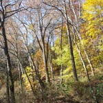
We’ll be focusing on the 1.1 acre, but it’s a great way to closely observe nature and follow the seasons in the park. On our visit on a bitterly cold February morning, we observed the Skunk Cabbage already emerging. And the frozen waterfall and Broomall’s Run have been lovely in the snow!
It’s a serene part of the park- we welcome you to visit it! It’s an introduction to the 1.1 acre, and a long farewell.
– Amy, Marcia, Shannon & Stephanie
Here are a few photos so far showing the 1.1 acre- you can click on any one for a closer look.
-
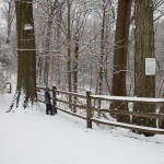
- Entrance at 3rd & West Streets – the existing path will become the access road for the construction project. There will be no pedestrian access from this entrance during construction.
-
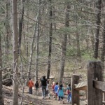
- School class on the path within the 1.1 acre construction area
-
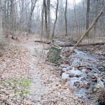
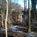
- View from near the current dam looking downstream- according to the engineers’ drawings, the new dam will cover everything up to about the fallen tree crossing Broomall’s Run. The construction area will extend beyond that.
-
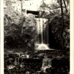
- The waterfall in its original glory- in a 1946 postcard
-
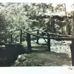
- 1930’s or 40’s photo of footbridge near waterfall. Posted with permission of Media Historic Archives.
-
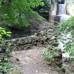
- Site of old footbridge by waterfall – this shows a footer for the bridge. Taken August 2011.
-
- Sycamores & wetlands at the base of Broomalls Dam in November 2011
-
- This shows much of the 1.1 acre from the site of the old footbridge, looking north across Broomall’s Run
-
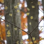
- American Witch-hazel in the 1.1 acre- where it is abundant!
-
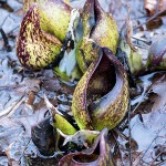
- Skunk Cabbage Spathes emerging in February 2013 – by Marcia Tate
-
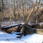
- Frozen waterfall in January 2013 by Susan Harrington
-
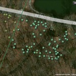
- These trees marked on Philly Tree Map are within the 1.1 acre construction area
Related Posts
Tags
Share This


Recent Comments